Author: cookies
Translation: Deep Tide TechFlow
With the continuous development of Web3 technology, the Decentralized Spatial Intelligence Network (DeSPIN) is becoming a highly regarded field. By analyzing and utilizing visual data from the real world, DeSPIN not only provides innovative solutions for map construction, urban planning, and robotics but also opens up a brand new "Contribute-to-Earn" economic model. This article will detail the core concepts, main protocols, and future development directions of DeSPIN.

What is DeSPIN?
Spatial Intelligence is a technology that extracts insights by analyzing visual data from the real world. Its core lies in combining geographic information with environmental context to support human decision-making. The Decentralized Spatial Intelligence Network (DeSPIN) integrates this technology with blockchain and the decentralized philosophy of Web3, forming an open and shared ecosystem. Imagine being able to earn rewards by sharing photos of roads taken in your daily life or recording environmental data in malls and streets. This model not only lowers the barrier to data collection but also incentivizes ordinary users to contribute to the development of spatial intelligence.
Before understanding the specific applications of DeSPIN, we need to grasp the basic framework of spatial intelligence. Spatial intelligence consists of four core components:
- Data Collection: Collecting data using sensor networks (such as cameras, GPS) and IoT devices (such as smartphones, laptops).
- Data Processing and Analysis: Utilizing machine learning techniques to process geographic metadata, identify patterns in the data, and build spatial query databases.
- Knowledge Representation: Associating data with environmental context through semantic mapping to provide users with visual geographic information.
- Decision Support Systems: Building spatial prediction models to provide users with application services, such as route optimization and obstacle avoidance.
Major Protocols in the DeSPIN Field
Currently, several innovative protocols have emerged in the DeSPIN field, focusing on different application scenarios. Here are eight noteworthy projects:
1. Hivemapper
Hivemapper is a decentralized map construction protocol that adopts a "Drive-2-Earn" model. Users report road issues in real-time through a mobile app, while drivers collect data using dashcams installed in their vehicles. This data is processed by AI algorithms to generate maps, which are validated for accuracy through human feedback reinforcement learning (RLHF). Hivemapper provides coverage maps, allowing users to see which areas have been mapped and access data via API. Data contributors can earn $HONEY token rewards, which can be used to purchase map data or other services.
2. NATIX Network
NATIX Network is a decentralized map economy protocol that focuses on collecting road data through mobile devices and dashcams, also using a "Drive-2-Earn" model. Its core technology, VX360, supports 360-degree panoramic data collection, and the collected data can be used to develop driving assistance features, such as autonomous driving optimization. Currently, NATIX Network covers 171 countries, with over 223,000 registered drivers and a total mapped mileage of 131 million kilometers. Both data contributors and network nodes can earn $NATIX token rewards, further incentivizing ecosystem development.
Hivemapper and NATIX are both committed to building higher-quality maps through crowdsourced road data. The potential application scenarios for this data are very broad, mainly including the following aspects:
- Optimizing urban traffic: By analyzing real-time collected road data, traffic flow management can be improved, congestion reduced, and travel efficiency increased.
- Monitoring road conditions: Timely detection and reporting of road damage, obstacles, or other potential issues help maintain the safety and reliability of infrastructure.
- Detecting crime and violent behavior: Using map data combined with AI algorithms can help identify and locate abnormal behaviors, supporting public safety.
These applications not only enhance the functionality of maps but also bring practical value to urban management and social safety.
3. FrodoBots
FrodoBots is a protocol for gamified data collection through robots, allowing users to remotely control ground robots to collect geographic data, supporting various operation methods (such as controllers, keyboards, or gaming steering wheels). Additionally, researchers can deploy AI navigation models for testing on the platform. Users earn FrodoBot Points (FBPs) by completing driving tasks, with points related to task distance and difficulty; the longer the distance and the higher the difficulty, the more points earned. FrodoBots has been tested in multiple cities and has hosted navigation capability competitions between AI and humans. Furthermore, FrodoBots has established a "guild"-like system called Earth Rovers School, allowing new users to participate in data collection by renting Earth Rovers.
4. JoJoWorld
JoJoWorld is a protocol focused on 3D spatial data collection, where users contribute data to help train three-dimensional models. The platform provides high-quality 3D data for creating various digital scenes, applicable in fields such as virtual reality and urban planning. Users can also directly purchase these 3D data for personalized digital model development.
The next four protocols also focus on collecting spatial data from the real world, but their application areas are more specialized, covering specific scenarios such as robot model training. These protocols inject more possibilities into the ecosystem of the Decentralized Spatial Intelligence Network (DeSPIN) by focusing on long-tail data and specific needs.
5. PrismaXAI
PrismaXAI is a protocol for collecting data from specific scenes through a first-person perspective, suitable for complex scenarios such as hand-object interaction, dynamic movement, and social gatherings. Its core technology, Proof-of-View, ensures the authenticity of the data while improving the accuracy of data annotation through a decentralized verification mechanism. This protocol has great potential in acquiring long-tail data, providing unique advantages for model training.
6. OpenMind AGI
OpenMind AGI focuses on understanding the real world through visual-language-action models (VLAMs). Its core system, OM1, is a multi-platform operating system capable of interacting with dynamic real-world environments, particularly suitable for customized development in robotics. The platform collects data through smartphones and robots, sharing this data with robot developers to improve and innovate robotic application scenarios.
7. MeckaAI
MeckaAI is a decentralized robot AI model training protocol where users help train robot behavior models by uploading video data. The platform provides a mobile app, allowing users to earn OG Mecka Points by completing tasks, further incentivizing data contribution. MeckaAI aims to promote the development of robotics through a crowdsourcing model, lowering the barrier to obtaining training data.
8. Xmaquina DAO
Xmaquina DAO is a decentralized autonomous organization (DAO) that supports open-source robot projects. Unlike other protocols that directly participate in model training, Xmaquina DAO's core goal is to support research and innovation in the robotics field through resource allocation. Its internal innovation center, Deus Lab, focuses on research and development in robotics, while MachineDAO votes on resource allocation to projects through staking the $DEUS token. This model provides funding support for the open-source development of robotics while ensuring transparency and fairness in resource allocation.
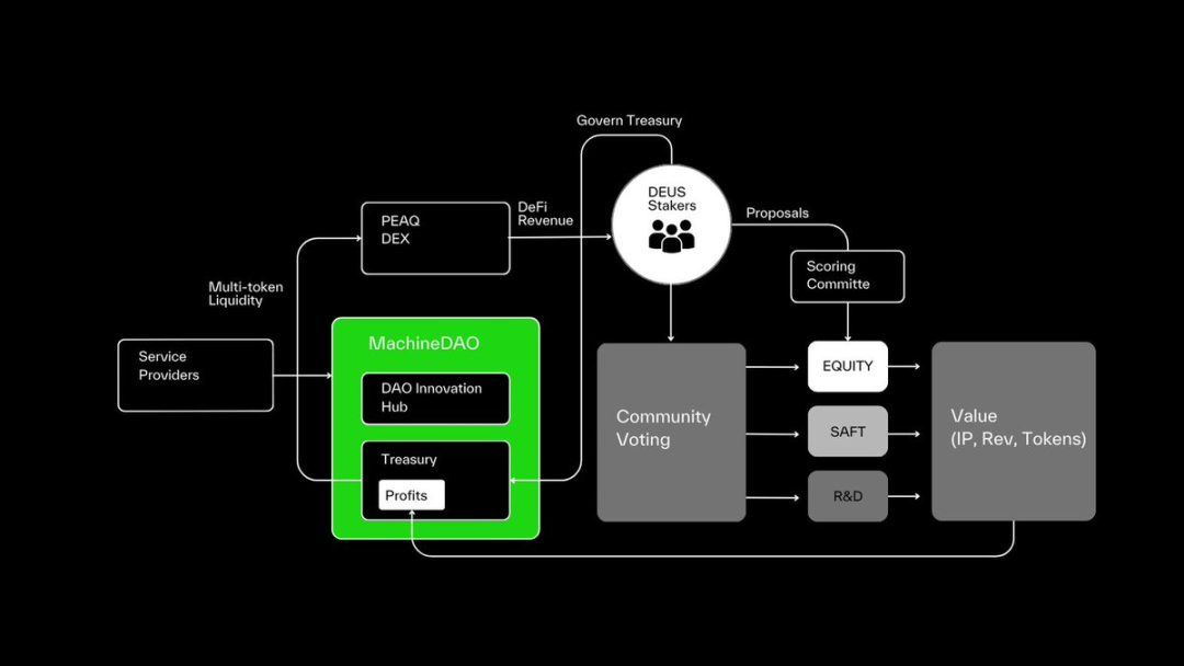
MachineDAO's Organizational Structure
Due to space constraints, there are other similar application protocols in the field that have not been detailed here, such as AlayaAI, Gataxyz, KrangHQ, etc., which are also worth attention.
The Future of DeSPIN: From Contribution to Value
Although DeSPIN is still in its infancy, its potential cannot be ignored. With the development of physical AI and embodied AI, as well as the emergence of new concepts like the Human Data Fleet, DeSPIN is expected to lead a new technological revolution.
One possible trend is the popularization of the "Train-to-Earn" (T2E) model, where users contribute value through spatial data obtained in their daily lives and receive rewards based on data quality. For example, the emergence of decentralized eyewear devices can greatly enhance the accuracy and diversity of data collection. The data captured by smart glasses not only reflects the way humans perceive the world most authentically but can also collect various environmental noise, facial features, and other long-tail data, bringing broader possibilities to the field of spatial intelligence.
However, the development of DeSPIN also faces some challenges, such as:
- Data Verification: How to ensure the authenticity and accuracy of crowdsourced data?
- Ethical Issues: How to regulate the use of data to avoid privacy breaches and misuse?
- Acceptance by Demand Side: Are traditional institutions willing to adopt decentralized datasets?
The resolution of these issues will determine the future direction of DeSPIN and requires further research and solutions in the future.
免责声明:本文章仅代表作者个人观点,不代表本平台的立场和观点。本文章仅供信息分享,不构成对任何人的任何投资建议。用户与作者之间的任何争议,与本平台无关。如网页中刊载的文章或图片涉及侵权,请提供相关的权利证明和身份证明发送邮件到support@aicoin.com,本平台相关工作人员将会进行核查。


